The Nameless Hurricane, 1913
- Charles Thrasher
- Aug 19, 2025
- 10 min read
Updated: Sep 29, 2025

Late in August 1913, a tropical depression formed halfway between Bermuda and the Bahamas. The wind began to swirl toward it like water around a drain. At 7:00 am Eastern Standard Time, August 30, it became a tropical storm. [1]
Slowly it began its trek toward the East Coast. By September 1, it had become a hurricane. Early on September 3, the storm peaked with maximum sustained winds of 85 miles per hour and a barometric pressure of 076 millibars (28.8 inches of mercury).
In 1913 the U.S. Weather Bureau, now the National Weather Service, had no name or categorization for circular storms. They were simply numbered. The September hurricane was the fourth of the season and the most powerful of the year.
Hours after the storm wind peaked, it made landfall near Cape Lookout, North Carolina.
The British steamship Glenaen wrecked on the Outer Banks that day. As well, the schooners Manteo, Grace G. Bennett, and George W. Wells. The Wells, with six masts, was one of the largest schooners ever built. [2]
The track of the storm backed westward as it passed between New Bern and Washington, placing Washington in the dangerous quadrant where the storm’s forward motion coincided with the direction of the circulating wind, increasing its velocity. At the height of the storm, 100 mph winds were reported in Washington.
As it moved inland parallel to the Pamlico River, the wind drove the water before it like a tidal bore 10 feet high. The shallow water of the Pamlico River slowed the forward speed of the waves and compressed their wavelength, making them steeper, more densely packed, and breaking more violently.
Calculating wave height from an 80-mph wind with a fetch of 20 miles over 6 hours, significant wave heights would likely have been 14 – 15 feet.
Significant wave height is the average height of the highest one-third of waves for a specific time. Maximum wave heights (the highest individual waves) would be roughly 1.5 – 2 times the significant wave height. The largest waves on the Pamlico River during the storm, measured from crest to trough, could have been 15 – 16 feet high, limited by the depth of the water. [See Erratum.]
A ten-foot breaking wave can exert as much as 1,000 pounds of pressure per square foot on impact. [3]
Nothing along the shore withstood the storm. The river, the main avenue of transportation for riverside farms, was lined with ramshackle piers where farmers loaded produce for market and fishermen from Ocracoke traded oyster shells for corn in summer. Fishing shacks and racks of seine nets were common along the river banks. The commercial fishing industry in Beaufort County had a reported value of roughly $325,000 – $400,000 in 1912-1913 (equivalent to about $10 million – $12 million today.) [4]
All of them were swept away.
From Maul’s Point, opposite Goose Creek, to the Pamlico Sound, on either side of the river, not a house survived, not a single boat of any description nor a seine or fishing net of any kind was saved. [5]
The Storm’s Arrival
Tuesday night, September 3, around 10 pm, Washington began to feel the gathering wind. By midnight, there was no escape from it. People were pinned in place wherever the wind found them.
Through the night people sheltered in their houses. Shingles rattled against walls like small arms fire. Uprooted trees crashed to the ground with the sound of field artillery. Water rose in the streets.
The night was thick with driven rain and airborne debris. Power poles fell and electricity failed. People were plunged into a darkness that exacerbated their fear. The sound of destruction was deafening. The earth trembled when massive elm, sycamore and cedar trees were driven to the ground.
The wind peaked around 4 or 5 am Wednesday morning and began to abate by 11 am.
In the poor sections of town, the water was so high that families had to abandon their homes and seek shelter.
People ventured out of their houses. The streets were impassible, clogged with downed trees, utility poles, and debris. Water stood several feet deep throughout the city. On Water Street it reached a depth of five to seven feet; on north Market Street, as high as six feet. Motor launches and row boats were used to navigate the business district. [6]
In the poor sections of town, the water was so high that families had to abandon their homes and seek shelter. It was estimated that at least five hundred slept in various churches on Wednesday night. [7]


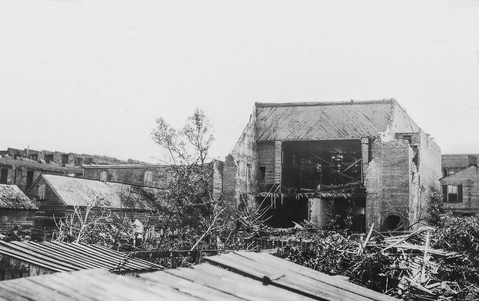
The Riverfront
Washington’s waterfront was ravaged by the storm. Fishing schooners moored at the city docks were carried upriver. The schooner Annie was found about a mile upriver of the bridge the Atlantic Coastline Railroad used for service between Washington and Vandemere. Two barges belonging to the Interstate Cooperage Company, loaded with lumber, were driven upriver and found hard aground two miles from Washington.


The Norfolk Dredging Company, under contract with the federal government, had one tug sunk at the U.S. Lighthouse Service buoy yard dock and another in the draw section of the nearby county bridge. The company also lost one of their dredges, the Reliance, sunk just below the Norfolk Southern Railroad bridge. Another tug was left high and dry near Rodman’s Creek.
By September 17, the Reliance had been raised and divers worked on patching the hulls of the tug Carolina, sunk at the buoy yard, and the Chowan, sunk at the Washington bridge. The salvage work drew a large crowd of interested citizens. [8]
The ubiquitous gasoline launches were piled ashore near W. M. Chauncey Marine Railway; others were deposited in the woods as far as a mile from the river. [9]
The docks would have suffered from the water rising beneath them and the impact of waves as well as the tension exerted by mooring lines before they parted. Docks were cheap, however, and quickly repaired.


Aftermath
Days after the storm, the Methodist church yard was still under water and standing water in the rear of the Maxwell bicycle shop on Market Street was still several feet deep.
Dr. John G. Blount, the Superintendent of Health, ordered home owners to pump dry their cellars and treat them with lime. “Any dead or decayed matter should be buried at once, all yards thoroughly cleaned and limed under and around the houses as much as possible.” [10]
Lime was used to disinfect outhouses and yards where floodwaters had left mud, debris, and organic matter. Quicklime (calcium oxide) was used to prevent the spread of typhoid fever, dysentery, and other waterborne or vector-borne diseases.


Not a single county bridge escaped destruction accept at Aurora. Both bridges crossing Bath Creek and the bridges at Belhaven and Blount’s Creek were carried away. The new steel bridge that cost $35,000 and spanned the Pamlico River between Washington and Chocowinity was also swept away by the flood. Row boats and gasoline launches were used to transport people across the river until the county could acquire a flat to use as a ferry service.
The Norfolk Southern Railroad lost their bridges across the Pamlico River, Jack’s Creek, and Runyon Creek. Their water depot where freight was stored before distribution on the river, including sheds, was also damaged. Their loss, both property and lost business, was estimated at $1 million (roughly $31 million in today’s currency).
The Atlantic Coastline Railroad bridge across the Tar River, the line that serviced Washington and Vandemere, was also destroyed.
The Norfolk Southern put 200 men to work repairing their bridge across the Pamlico River; the Atlantic Coast Line employed 100 on their bridge crossing the Tar. Both bridges were rebuilt sooner than expected. The first Norfolk Southern train crossed the Pamlico the night of September 13, 10 days after the storm. [11]


Stories of the Flood
Stories emerged in the days after the storm.
Captain E.H. Derrickson, commanding the barge Berks under tow with 394,700 feet of lumber consigned by the Neuse River Lumber Company, New Bern, to the Henry Dickson Sheets Company, Philadelphia, was thrown into the water when the barge went to pieces between Gull Rock and Bluff Shoal on Pamlico Sound.
It wasn’t Captain Derrickson’s first experience. He had been previously shipwrecked at Beaver Tail, then Phinwick’s Island, Gum Pickett Shoal, and finally Gull Rock.
The crew consisted of himself, two negro seaman, and a dog. After clinging to a piece of wreckage for 28 hours, Derrickson was rescued by Albert Best of Stumpy Point and put ashore at Engelhard.
The captain was the only survivor. The body of one of the crew was later found at Juniper Bay and buried.
Captain Derrickson had been at sea for 40 years before the wreck of the Berks. The Washington Daily News didn’t mention whether the captain intended to retire. [12]
A resident of Belhaven was bedridden with typhoid fever. As the water rose, he was moved to the second story. The water continued to rise until his mattress was again awash. He was passed through a window and rescued by boat.
Captain McBinson was fishing in the Pamlico River. His boat was caught by the wind and carried rapidly towards the woods across C.H. Sterling’s farm land. His boat lodged among some trees. Sterling’s farm manager, Mr. Stoneham, called out to McBinson for his family to be rescued. A few moments after Mr. Stoneham and his family were taken onboard, the boat was torn from its mooring and made for the woods. All were saved. [13]
Remarkably, no one in Beaufort County died because of the nameless storm of 1913 but the high water mark it left on Washington remains a record never exceeded.


Notes
[1] 1913 Atlantic hurricane season; Wikipedia.
[2] 1913 storm thrashed ships, and a rescue led to accusations, September 9, 2021, CoastalReview.org.
[3] Coastal Engineering Manual and Shore Protection Manual, U.S. Army Corps of Engineers
[4] U.S. Bureau of Fisheries report covering 1912-1913
[5] Washington Daily News, September 8, 1913: 1
[6] Washington Daily News, ibid
[7] Washington Daily News, ibid
[8] Washington Daily News, September 17, 1913: 1
[9] Washington Daily News, September 8, 1913: 1
[10] Washington Daily News, ibid
[11] Washington Daily News, September 12, 1913: 1
[12] Washington Daily News, ibid
[13] Washington Daily News, ibid

Erratum:
Several knowledgeable people have raised the question whether the shallow depth of the Pamlico River could support a maximum wave height of 24 feet, my initial estimate. It’s a legitimate question.
When initially calculating wave heights, I took into account only wave dynamics resulting from a wind force of 80 mph across a fetch of 20 miles and a period of 6 hours without accounting for the river’s depth.
The controlling depth of the channel from the Pamlico Sound to Washington in the early 20th century was only about 9 feet. However, the estimated hurricane surge on the river added an additional 10-12 feet.
Using the U.S. Army Corps of Engineers Shore Protection Manual (SPM ) / Coastal Engineering manual (CEM) formulas with data input of water depth 20 feet, wind speed 80 mph, and fetch of 20 miles, it's possible to derive the following:


In the depth of the channel, significant wave heights could have been as much as 14 -15 feet but the depth of the water would have limited maximum wave heights to 15-16 feet. In shoal water at the edge of the channel, maximum wave heights would have been reduced.


Comments